Sunday, July 28, 2013

Bay Trail through Oakland Airport

An adventuresome ride south from Alameda through the Oakland Airport and San Leandro marina. There's interesting sights, several bridges, lots of airplanes, and it's mostly bike friendly for a 5th grader. We did 22 miles out and back and since this is the Bay Trail you can easily lengthen or shorten the trip.

Today we drive to the ride, taking 880-S to High St exit. Go straight down the ramp then take the second right onto High Street, the first right doubles back onto Alameda Avenue.
After crossing High Street bridge we go left on Fernside and park on the west side just past Lincoln Park. There's a wide bike lane along Fernside south of High Street. You can continue about 10 blocks, turn left and park on Madison or Washington if you don't want to cross Fernside on your bike.
Cross from the west side to the east side of Fernside Drive using the crosswalk at San Jose to join the 2-way class I/II separated bike lane.
Over the bridge we go left and hug the shoreline.
After crossing Doolittle Drive the bike path is on the sidewalk along Bay Harbor Parkway. It's bumpier than the road but not too bad.
At the end of Harbor Bay Parkway turn left onto Ron Cowan Parkway.
Ron Cowan Parkway has a super wide and clean shoulder and traffic is low early on a Saturday afternoon.
The separated class I bike path starts about halfway down the parkway.
The path is pretty dirty with gravel and there's a few grates to watch out for when it's wet but it's nice to be on a safe bike lane.
The bike trail is clean and smooth, and Linc loved looking at the airport.
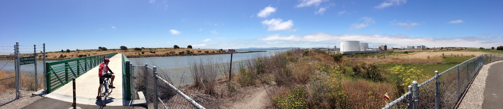
The "Bill Lockyer" bridge south of the airport is new and wide.
We watched a Southwest plane landing.
After the bridge we went right, continuing on Oyster Point shoreline.
After exiting Oyster Point park we turn right on Neptune. I've always liked this neighborhood, quiet and close to the water.
The trail joins the road for a short stretch through the marina.
At the south end of the marina go through the gate and across the bridge to the paved hiking/biking trail.
Bay Trail scenery here is the more familiar rock-fill shoreline on one side with salt marshes on the other.
Looking east towards the hills.
Linc was really curious how this boat ended up here. I think he had half a mind to try and flip it over and take it home.

We turned around at the end of the paved section (about 2 miles from gate). We could have continued south on dirt trails all the way to San Mateo bridge and onto the BART station in Hayward but we left that for another day. We rode into the typical strong afternoon headwinds on the way back north.

Rails still to come for the train connecting Coliseum BART station to the airport.

Here's the well marked crosswalk under the busy main airport access road. There's an audible signal when the crosswalk is green.
Back over the last bridge to Alameda island.

Sunday, March 10, 2013

P1 * V1 / T1 = P2 * V2 / T2 the Combined Gas Law

Why does ice form on outflow pipes of gas cylinders or storage tanks?


The reason you get ice on a propane tank when you are burning fuel or bleeding the gas is explained by the Combined Gas Law (CGL)

The law states that for any gas the Pressure times the Volume divided by the Temperature is a constant. Constant means it's always the same.

PV/T = k   

I think I can explain using a gas barbecue propane tank as an example.

First, you want lots of gas in the tank in order to cook for a while. To get the gas in you pressurize or squeeze it. (As you squeeze gas molecules closely together gas turns into a liquid, this is why you feel liquid sloshing around a propane tank after a re-fill)

A full gas cylinder starts at about 130 pounds per square inch (psi) of pressure at 72 degrees F. The pipes which the gas flows through run at a lower pressure. A regulator valve controls the flow between high pressure tank and lower pressure pipes. By limiting gas pressure in the pipe a regulator provides a controlled flow of gas over a long time.

With a regulator connected and burners open gas flows out through the burners because pressure in the pipe is higher than outside air pressure (about 14 psi), and as long as the pipes are at lower pressure than the tank gas continues to flow out.

With a full tank the pressure differential is large and gas flows out fast, we often hear it roaring out and see it burning bright blue. It takes us 7 to 8 days to burn a 5 gallon tank camping and by week's end the flow is very slow and quiet.

When gas flows out internal tank pressure drops slowly so the tank temperature will drop to preserve PV/T = k ratio. However the effect is not big and would not explain ice on the outflow pipes we see above.

Back to the barbecue, (assuming it's not windy) we see a fairly steady flame. This shows the volume of gas inside the hose is stable. Think about it this way, gas flows in and out of the hose at the same rate so the volume of gas does not change inside the hose, it changes in the tank.

The only way to preserve the "k" gas ratio in the outflow valve and pipe with a steep Pressure drop and no Volume change is for gas Temperature to drop. Remember PV/T = k, and k does not change.

So the gas flowing out needs to drop temperature quickly to obey the Law, which causes the outlet valve and pipes to become very cold. Water vapor in the air condenses on the ultra cold surfaces and freezes.

You see ice on those pipes when gas is flowing out because it's the Law!


Two piers

Had not noticed the arches on both sides of the pier before. That lower level must have been one busy work area about 70 years ago.


The old pier from the new viewing pier.


Ford Point

The 84 foot carbon fiber catamaran USA 76, 2003 Americas Cup competitor converted to charters and tours, sailing out past Ford Point.

Thursday, February 28, 2013

Bayview spur

Just off the Bay Trail, looking SE next to the bridge to Bayview Ave.


Is this a tidal wetland or salt marsh?

I've been taking the bridge to Bayview Avenue then Meade Street and up to the top of Regatta when the waterfront trail is busy, there's almost no traffic (but you do get freeway noise).

Meade takes you past the Richmond Field Station future home of a Lawrence Berkeley National Laboratory campus. That seems like a good development for this corner of Richmond. Amini's is going to be busy at lunch once the lab is running.


Monday, February 25, 2013

Marina Way 2

South end Marina Way again, around sunset


Sunday, February 24, 2013

Richmond Waterfront from Barbara and Jay Vincent Park

View from the hilltop at the west end of Barbara and Jay Vincent Park on the Richmond waterfront. The boxy ship with white superstructure to the left of Ford building is a car carrier, a Honda ship I think. The WWII Victory-class merchant mariner Red Oak Victory is to the left of the car carrier.


This is a wider panoramic view from the same hilltop. There's a great play area with swings and slides and a big lawn off to the right. The waterfront is consistently windy and this little peninsula in particular can be a nice cooling off spot for the kids on a hot day. 


Friday, February 22, 2013

Marina Way, Richmond Waterfront

South end of Marina Way overlooking the waterfront bike path.


The Boiler House restaurant in the Ford Building (under silver smoke stack) is closed, it is going to re-open as Assemble.  We're hoping to stop by on a bike ride for a burger once they open, it's a great setting for a waterfront cafe.

Tuesday, February 19, 2013

Flags of Convenience

The Stolt Saphire, a 38,746 ton tanker, moored at the same wharf where the USS Iowa berthed for a few months during it's retrofit.

The ship is registered in Monrovia (Liberia). I doubt the ship has ever been there, there's no  company office near there, and I doubt any of the owners have been there either. Flying a flag of convenience  

The company has a bunch of ships registered in Liberia and Cayman Islands, I'd guess they are pretty typical given how high a percentage of the world's shipping is registered under a flag of convenience.

Monday, February 18, 2013

Richmond Shipyard #3

Richmond Shipyard #3 at sunset, looking East at North slip.


Kaiser built 4 shipyards in Richmond with the largest shipbuilding capacity in the US, assembling a total of 747 Ocean (pre-Liberty), Liberty, Cargo Ship (pint size Liberty), C4 Transports, Frigates, LSTs and Victory ships.

The big Whirley crane in the background had a 110 foot long boom and could handle up to 83 ton (166,000 pound!) loads. It got it's name from it's novel ability to spin in a full circle. The cranes lowered iron gates into the water to convert the slip into a dry-dock, with pumps removing up to 50,000 gallons per minute.

Red Oak Victory is the big grey ship in back, you can see the 3 inch bow gun just above the right end of the white Matson container. 534 Victory-class ships were built and she is 1 of the last 2 still floating.

On the very left the 205 foot long 950 ton Wapama, a 1915 lumber carrier, is hauled up on the pier being restored. According to the Library of Congress Wapama was the last working ship of 225 West Coast steam schooners built from around 1880 to 1923. The CA Thayer in San Francisco and Wawona in Seattle, WA are other examples.

You can see a 5 ton fragment of another steam schooner the Point Arena (1887) at Año Nuevo State Park. The Point Arena, one of the first steam schooners built with an engine, was loading at Pigeon Point "doghole" harbor (tiny unprotected rocky inlet) in 1913 when a large wave snapped a mooring line and the hull was torn open on a rock. The dangerous small, unprotected and rocky harbors of the West Coast claimed many ships in this class.

Nice to be out on the bike again.